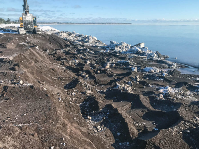
An excavator is used to remove stamp sands from the beach directly north of the breakwater at the Grand Traverse Harbor. (Photo provided by Michigan Department of Environment, Great Lakes and Energy)
<!–
By GARRETT NEESE
Houghton Daily
Mining Gazette
LAKE LINDEN — For a century, winds and currents have swept copper tailings from the Wolverine and Mohawk mines from Gay to an area five miles down the shoreline to the Buffalo Reef area off of Grand Traverse Harbor.
An interagency task force has spent three years evaluating the best options for removing and storing the stamp sands threatening the reef, a historic spawning grounds for lake trout and Lake Superior whitefish. Next month, it will announce its preferred plan to the public.
The meeting will take place 6 p.m. July 12 at the Lake Linden-Hubbell High School auditorium at 601 Calumet St. in Lake Linden.
In 2019, the task force narrowed the list to three preferred alternatives from among 13 strategies being considered. Those three were considered the most feasible, said Jay Parent, district supervisor for the Michigan Department of Great Lakes, Environment, and Energy’s Upper Peninsula District Office in Marquette.
The three finalist action plans include:
≤ Building a retaining wall to contain the stamp sands at the original pile, as well as the stamp sands dredged from the lake and beach.
≤ Building a landfill in an upland area near the community of Gay for the stamp sands removed from the lake and beach.
≤ Placement of stamp sands removed from the lake and beach in the tailing basins at the former White Pine Mine in Ontonagon County.
After releasing an analysis of 13 potential options in February 2019, the task force sought public comment on any adjustments in management strategies or risks in the draft analysis, or whether there were other ideas the task force should consider, the DNR said in a news release.
The task force then met in June 2019 to begin reviewing the 13 alternatives and narrowing it down to the three options, which would then be fleshed out with costs and evaluated for feasibility.
Discarded options included putting the stamp sands in mines (“The mines are flooded, and you can’t just put them down the shaft,” Parent said) and building a new reef (“That’s very difficult to do, and you don’t know if they’re going to work”).
Once the task force had three final options, a team of engineers and scientists spent several months weighing the risks and benefits of each option, and projecting the costs to put them in place. The public and a variety of experts helped narrow the list down.
With a final option identified, the next steps in the process include finding the required funding and sponsor, then designing and implementing the preferred plan.
The sponsor must be non-federal. Typically, that will be another government entity at the state or local level, Parent said.
The cost of the plan hasn’t been determined yet, as it’s still in the planning stages. However, it’s expected to reach more than $1 billion, Parent said.
The reef contributes about 30% of the lake trout caught within 50 miles of the reef, according to the Great Lakes Indian Fish and Wildlife Commission.
The U.S. Army Corps of Engineers removed about 157,000 cubic yards of stamp sands in the harbor in 2019 through $3.7 million in EPA funds. In October 2019, Michigan DNR’s contractor removed 175,000 cubic yards of stamp sands — a 30-foot cliff — from the water’s edge at Gay, the DNR’s Buffalo Reef website said.
Maintenance dredging every year since removes about 40,000 cubic yards a year, Parent said.
That’s been enough to keep the harbor clear and keep the sands from overtopping it and reaching the sand beach, Parent said. The sands are trucked about four miles north to a Corps of Engineers storage area of existing stamp sands.
“Eventually, if nothing’s done, the lake’s going to eat away at the pile and get into it,” Parent said. “We don’t have a good spot to put it, so that’s what this final plan is going to lay out.”
The project to save the 2,200-acre reef — which is being funded through the Great Lakes Restoration Initiative and a combination of state and tribal funds — is being executed in cooperation between the U.S. Army Corps of Engineers, the U.S. Environmental Protection Agency, the Bay Indian Community, the Great Lakes Indian Fish and Wildlife Commission, the Michigan Department of Natural Resources and the Michigan Department of Environment, Great Lakes, and Energy.
For more information on the ongoing Buffalo Reef effort or to sign up for email updates, visit Michigan.gov/BuffaloReef.


